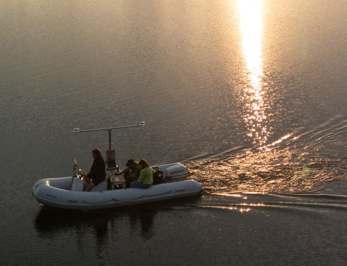
We are excited to announce that the Centre for Underwater Archaeology at Nicolaus Copernicus University in Toruń has acquired one of the most advanced tools to study aquatic environments – a Multibeam Echo Sounder (MBES) system. This technology, which has been a staple in hydrography and oceanography for years, opens new horizons for exploring, documenting, and analysing cultural heritage hidden beneath the water’s surface.
What is Multibeam Echo Sounder (MBES)?
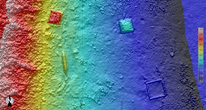
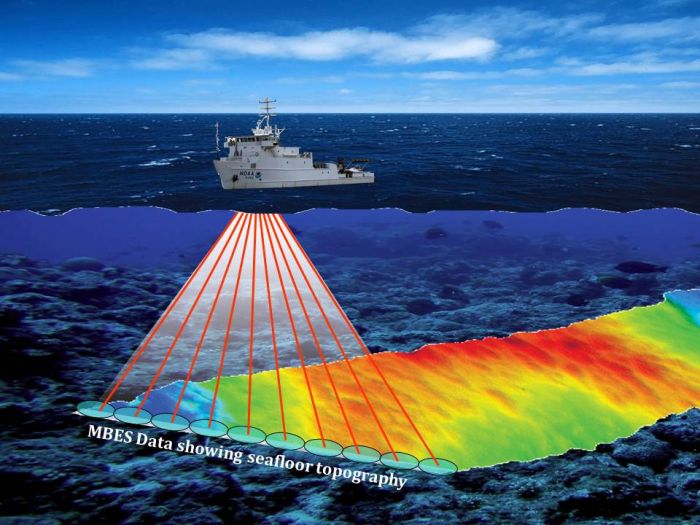
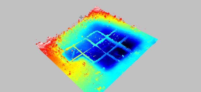
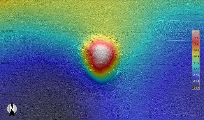
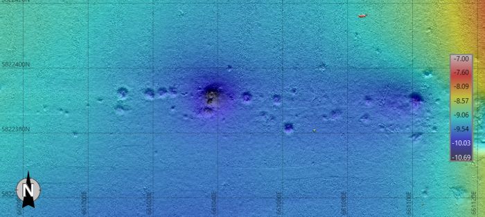
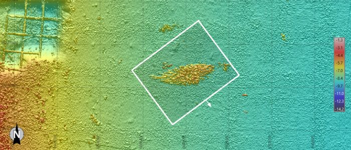
It’s a type of sonar that emits hundreds of acoustic beams arranged in a fan shape from the transducer, scanning the seabed (or lakebed) over a wide swath. By measuring the return time of each beam and synchronising with D-GPS, the system generates an exceptionally accurate 3D model of the underwater terrain. But that’s not all. MBES also records something known as backscatter – the intensity of the acoustic reflection from the seafloor – which allows for the analysis of sediment type and structure. In short, this system lets us see what the bottom looks like and understand its composition and how it may have changed over time.
What will MBES bring to the work of underwater archaeologists at NCU?
For us as underwater archaeologists, this is a revolutionary tool. Traditionally, underwater research has meant long hours of diving, slowly combing small bottom sections with a high degree of uncertainty about what lies ahead. MBES allows us to survey vast areas of aquatic terrain quickly, pinpointing with great accuracy the locations where we are most likely to find submerged structures, shipwrecks, human activity traces, or environmental changes. Instead of "looking for a needle in a haystack," we can now focus our efforts on the most promising areas, which we can examine in more detail using divers.
Planning our fieldwork will now reach an entirely new level. Before our divers even enter the water, we will already have detailed bathymetric maps, topographic models, and data on sediment types. This drastically reduces the time needed for preliminary reconnaissance and allows our team to concentrate their efforts where discovery potential is highest. Moreover, the ability to generate high-resolution 3D models of the bottom means our documentation will be more precise and more compelling – for both the academic community and the broader public.
Where can MBES be used?
One of the greatest strengths of MBES technology is its independence from water visibility. In conditions where cameras see only murky whiteness, sound waves continue to travel and return valuable data. This is a huge advantage in freshwater environments like lakes and rivers, where visibility often drops to near zero. Thanks to MBES, we’ll be able to conduct research in a far wider range of aquatic environments – not only in clear waters but also in difficult, turbid ones that have so far remained nearly inaccessible.
The potential of MBES goes far beyond simply detecting structures. The system also enables the analysis of microfeatures on the bottom, such as paleo-riverbeds, submerged settlement traces, ancient shorelines, or environmental changes related to human activity. This will give our research a palaeoenvironmental dimension, which will enable us to develop cooperation with other researchers from Nicolaus Copernicus University.
Upcoming plans
Our first activities using the MBES will involve pilot studies – test scans at known archaeological sites in the lakes of northern and central Poland, including Lake Lednica. These trials will allow us to test workflows, calibrate the equipment, and prepare for full-scale field campaigns. At the same time, we are launching a specialist training program for our team in terms of operating the device and advanced data processing.
In the coming months, we plan to use MBES for preliminary mapping of potential archaeological sites, as well as for cooperation with scientists from Nicolaus Copernicus University and other research centres and museums.This new equipment will become a scientific tool and a platform for collaboration and knowledge-sharing within the archaeological community in Poland and beyond.
MBES and popularisation of research results
It’s important to emphasise that MBES technology is not just a scientific asset – it also holds enormous potential for public outreach. 3D models, interactive bathymetric maps, and underwater visualisations can become powerful educational tools, helping to communicate the beauty and importance of submerged heritage. We’re already considering projects to bring this data to museums and broader outreach initiatives. Underwater archaeology is becoming more accessible, tangible, and understandable to the broader public.
A new chapter at the Centre for Underwater Archaeology
The acquisition of a Multibeam Echo Sounder is an investment not only in technology but in the quality and future of our research. Thanks to this, the Centre for Underwater Archaeology at Nicolaus Copernicus University in Toruń can become a leader among research centres that can conduct world-class research in a modern, efficient and interdisciplinary manner. It also reflects our ongoing commitment to advancing research standards and pushing the boundaries of what is possible in underwater archaeology.
We would like to take this opportunity to thank all the individuals, institutions and partners who supported our initiative: the Nicolaus Copernicus University's ‘Initiative of Excellence – Research University’ (IDUB) programme and the Dean of the Faculty of History at Nicolaus Copernicus University. We are entering an exciting phase of discoveries, learning, and new scientific challenges. We are confident that MBES will become our invaluable ally in uncovering the past beneath the waves.
We invite you to follow our upcoming work – very soon, and we’ll share the first scan results, 3D bathymetric models, and documentation from our field campaigns. Underwater heritage awaits – and we are ready to explore it with unprecedented precision.
This is not our first encounter with this type of device. We have been analysing MBES data provided by other units for years. If you would like to see the results of this cooperation, we recommend our publications:
Janowski, Ł., Pydyn, A., Popek, M., Gajewski, J., & Gmińska-Nowak, B. (2024). Towards better differentiation of archaeological objects based on geomorphometric features of a digital elevation model, the case of the Old Oder Canal. Archaeological Prospection , 1–12. https://doi.org/10.1002/arp.1927
Janowski, Ł., Skarlatos, D., Agrafiotis, P., Tysiąc, P., Pydyn, A., Popek, M., Kotarba-Morley, A. M., Mandlburger, G., Gajewski, Ł., Kołakowski, M., Papadaki, A., & Gajewski, J. (2024). High resolution optical and acoustic remote sensing datasets of the Puck Lagoon. Scientific Data , 11 , Article 1. https://doi.org/10.1038/s41597-024-03199-y
Janowski, Ł., Pydyn, A., Popek, M., & Tysiąc, P. (2024). Non-invasive investigation of a submerged medieval harbour, a case study from Puck Lagoon. Journal of Archaeological Science: Reports , 58 , 1–12. https://doi.org/10.1016/j.jasrep.2024.104717
Pydyn, A., Popek, M., Janowski, Ł., Kowalczyk, A., & Żuk, L. (2024). Between water and land : connecting and comparing underwater, terrestrial and airborne remote-sensing techniques. Journal of Archaeological Science: Reports , 53 , 1–10.
Pydyn, A., & Popek, M. (2022). Badania nieinwazyjne podwodnych stanowisk archeologicznych. W M. Kostyrko, A. Kowalczyk, A. M. Wyrwa, & L. Żuk (red.), Między ziemią, wodą i powietrzem : metody nieinwazyjne a dziedzictwo archeologiczne Lednickiego Parku Krajobrazowego (T. 43, s. 129–139).
Janowski, Ł., Kubacka, M., Pydyn, A., Popek, M., & Gajewski, Ł. (2021). From acoustics to underwater archaeology : deep investigation of a shallow lake using high-resolution hydroacoustics : the case of Lake Lednica, Poland. Archaeometry, 63, 1059–1080. https://doi.org/10.1111/arcm.12663
Pydyn, A., Popek, M., Kubacka, M., & Janowski, Ł. (2021). Exploration and reconstruction of a medieval harbour using hydroacoustics, 3-D shallow seismic and underwater photogrammetry : a case study from Puck, southern Baltic Sea. Archaeological Prospection, 28, 527–542. https://doi.org/10.1002/arp.1823